.JPG) |
Ride 050.
|
|
.JPG)
|
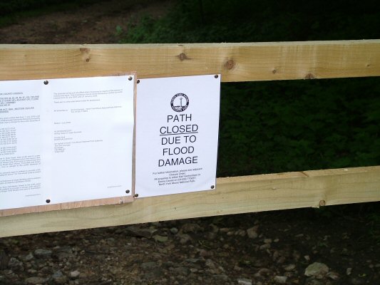
Date: 5th July 2005 Distance: 14 miles Terra Trailblazers have notched up a half century of group rides, a celebratory ride along flowing singletrack, beneath a blue sky ought to have been the order of the day. Instead a grey afternoon in North Yorkshire transpired, the only celebration being that it wasn’t actually raining when we set off. The British summer returns with vengeance. The initial start, up The Mad Mile from the Square Corner car park, proved especially taxing for me as I’d just returned from two weeks cycling in a magical place where all the uphills involved nothing more strenuous than hooking the bike onto the side of a cable car. Reacquainting myself with piloting a bike against gravity would take some time. Some erosion was present on the as we huffed and puffed our way to the top, apparently there was a major cloudburst last month which had done quite a bit of damage around and about. We arrived at the cairn just in time for it to begin a steady drizzle which would accompany us for the remainder of the ride. After regaining our breath, coughing up lumps of bloody lung-tissue and generally recomposing ourselves, we headed south along the drove road until we reached the bridleway heading east into Thorodale, a classic descent which Chris had yet to sample. A newly erected signpost at the beginning of the bridleway was bypassed without being read – mainly because it was on the more southerly side of the track and would have required a detour, this proved to be a significant oversight. The descent into Thorodale was a little slippery, owing to the rain but fun nonetheless. The gentle, meandering stream in the valley bottom appeared to have ripped a new deeper, wider, path through the grass, more evidence of the force of the Father’s day downpour. The gate leading into North Moor Wood had a notice fastened to it, something about paths being closed because of flood damage, footbridges down etc., it couldn’t apply to us because I didn’t remember any footbridges on our route through the woods, so off we went. The woods were a little muddy but quite rideable and all was well until the path reached the outskirts of Arden Hall, turning to a wide farm track, our way barred by a newly erected fence and yet another path closed notice, this time festooned with red and white tape. Just like in the horror movies where the stupid teenagers ignore every warning and continue straight into deeper trouble, under the tape we went and along the road – but only briefly because soon there wasn’t a road just a fifteen foot deep crevasse where the road used to be. So that’s what the signs were trying to tell us! Various crossing options were discussed, mostly unfeasible, mainly involving Eval Knieval, body armour and ultimately South Cleveland Hospital. We bushwhacked an alternative route down, across and up the gorge, emerging on the other side of the breach with only minor injuries and nettle stings. Knowing our planned route involved four more water crossings any sensible people would have rearranged the route or used the road but on the other hand nothing could have been as bad as what we had just crossed so disregarding more white notices we continued blithely onward. The river Rye in Low Wood, in the valley between New Hall and Hill end House showed just how ferocious and high the water had been, log jams lined the banks and silt spread inland 10 metres either side of the river, naturally the bridge was no more but a new set of stepping stones upriver made it easy to cross. Joining the road at Moorgate a road closed sign indicated even the tarmac alternative would have been unfeasible. We pedalled steadily up the track to LowThwaites, the wind and rain behind us giving a little assistance, prior to turning left and ploughing down through the heather on the infamous disappearing bridleway to Lane House Farm at Snilesworth. Only the Dale Head singletrack to go and we’d be back at the car park – the ideal place for my freehub to give up, spinning madly and going nowhere, could almost be the TTB motto. A bit of emergency maintenance, utilising a deep pool in the stream, a lot of banging the back wheel up and down and assorted swear words had it working after a fashion, so long as I didn’t put to much power down. Completed the route in true Simon style – in the granny ring. More of an epic adventure than a bike ride, over four hours to cover 14 miles, 5 (bridgeless) river crossings and one knackered hub; soaked to the skin, nettle-stung and thorn-scratched. Summer in England.
Height Profile: (click to enlarge)
|

.JPG)
.JPG)
.JPG)
.JPG)
.JPG)
.JPG)
.JPG)
.JPG)
.JPG)
.JPG)
.JPG)
.JPG)
.JPG)
.JPG)
.JPG)
.JPG)
.JPG)
.JPG)
.JPG)
.JPG)
.JPG)
.JPG)