|
Monthly Update March 2013
|
||
.jpg) .JPG) .JPG) .JPG) .JPG) .JPG) .JPG) .JPG) .JPG) .JPG) .JPG) .JPG) .JPG) .JPG) .JPG) .JPG) .JPG) .JPG) .JPG) .JPG) .JPG) .JPG) .JPG) .JPG) .JPG) .JPG) .JPG) .JPG) .JPG) .JPG) .JPG) .JPG) .JPG) .JPG) .JPG) .JPG) .JPG) .JPG) .JPG) .JPG) .JPG) .JPG) .JPG) .JPG) .JPG) .JPG) .JPG) |
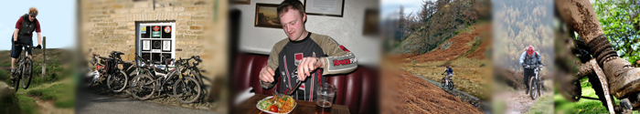
6th March 2013. 13 miles. 1425ft ascent. Ride map. Still the winter continues. Our first ride of the month was just a scrounge about Guisborough Woods and the surrounding moors, taking in Codhill Heights, The Secret Path and The Chute. Despite the snow which lingers, the tracks were relatively dry. If I remember correctly, it turned misty and the highlight of the ride day was a 64 year old taking up residence in a hollow tree.
7th March 2013. 31 miles. 1154ft ascent. Ride map. Another local ride on the cross bike, mud and headwind conspiring to make life difficult. Came as close as ever to ‘bonking’ through lack of fuel, despite breaking into the emergency pack of winegums in my back pocket. Made it home where I managed to eat my pre prepared (healthy) lunch, followed by a bag of crisps and a full box of Jaffa cakes before the shakiness abated.
12th March 2013. 24 miles. 1050ft ascent. Ride map Cross bike came out again for a local ride with young Scott, we stayed local to avoid the blizzards which were forecast to hit North Yorkshire. We went on the normal Wynyard, Castle Eden, Carlton sort of route. Scott got a PB for the most miles he’s ever ridden in one go.
13th March 2013. 12.5 miles. 1546ft ascent. Ride map. The middle of March and we’re back to winter wonderland, or Guisborough Woods is, shame it’s a week until the start of spring - if it ever happens. We had a slip and slide through the woods and up to Gribdale, where we hiked up the steps to Newton Moor while The Pensioner decided to use one of his special shortcuts which actually take significantly longer in both distance and time than the way the rest of us went. We idled our time away waiting for him by making direction signs in the snow, so we could could ride ahead before hypothermia and frostbite set in. Later we made an accident strewn descent of The Chute, the snow covering ensured everyone hit the deck at some point but only The Pensioner was kind enough to perform for the video.
14th March 2013. 17 miles. 1750ft ascent. Ride map. Third day in a row, this time we found ourselves in the car park at Sheepwash, rather less snow than Guisborough but destined to get deeper as we went higher. Highlight of this ride was our ascent of The Mad Mile, first ever, dab-free ascent in one case. Of course it has been sanitised in the worst possible way, the old slippy, slabby, rock strewn descent was much preferable to the boring mediocrity of the gravel track it has become, even if we can now ride up it. We made our way across a snow-covered Drove Road to Boltby Forest for a descent of Atlay Bank, the brace of rocky, rhododendron-choked gullies was good but the linking section was muddy hell. The countryside bit back when I fell off in some mud and had my cheek speared by a dead bracken stalk. A little bit of tarmac through Kepwick brought us to Silton Woods and the horrendous fire road ascent back to Square Corner. It is still horrendous.
20th March 2013. 49 miles. 2235ft ascent. Ride map. Road ride, Carlton Bank, Clay Bank, painful, that’s all I’m saying.
21st March 2013. 25 miles. 1827ft ascent. Ride map. Strangely fresh considering yesterday's ascent. We had a mountain bike ride from Birk Brow, starting by checking out a track near the car park, marked on the map as Jenny Fiske Road, we won’t be riding it again anytime soon. The remainder of the route continued in a more predictable manner, Robin Hoods Butts, Danby Beacon, Lealholmside, Lealholm, Ainthorpe, Danby and returning over the Quakers Causeway.
22nd March 2013. 12 miles. 1581ft ascent. Ride map. Another day: another bike ride. Another Pinchinthorpe start, The Captain joined us for his second ride this year and what turned out to be his briefest ride ever, he threw the towel in before we’d even rode a mile from the car park and retired owing to some previously undisclosed ailment. We spent a some time in Cliff Rigg Quarry, where the younger ones pretended they could “get some phat air” Later in the ride, taking in some typical Guisborough Woods, Scott managed several body/tree interfaces, which more by good luck left him and his bike relatively unscathed.
25th March 2013. 31.5 miles. 905ft ascent. Ride map. Wind, powerful stuff isn’t it? I was averaging almost 17 mph for this ride until I turned into the wind and began the slog home.
28th March 2013. 19.5 miles. 2,092ft ascent. Ride Map Somehow found ourselves with a big crew today, it’s not even an Xmas dinner ride. Met up at Sheepwash and did the old Scugdale round. Scarth Wood Moor, Clain Woods, along the Scugdale Valley, up the B.O.A.T., Barker’s Ridge, Arnesgill Ridge to rejoin the road at Low Cote Farm. The moorland tracks are surprisingly dry probably the effects of the pretty constant easterly wind we’ve had for weeks. Whatever the cause we’re not complaining and it was brilliant to be cruising across the moors on hard, sandy tracks. We finished the ride clean and happy.
Terra Trailblazers March 2013 riding from John Lavelle on Vimeo.
|